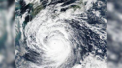
On Thursday, Super Typhoon Yagi intensified into a Category 4-equivalent storm in the South China Sea, marking it as one of the strongest typhoons in the region’s history. The storm is expected to impact southern China, Hainan Island, and Vietnam, with wind speeds exceeding 160 km/h in some areas.
Yagi’s trajectory is anticipated to influence Canada’s weather patterns by mid-September. While the typhoon itself won’t directly cause the pattern change, its path suggests a higher likelihood of a significant shift in weather.
Super Typhoon Yagi’s track is expected to lead to a weather pattern change in Canada, resulting in ridging that will bring above-normal temperatures and drier conditions. This could create a spell of weather that feels more like mid-summer, making the final full weekend of summer particularly pleasant. Southern Ontario and southern Quebec could see daytime highs ranging from the mid-20s to around 30 degrees.
Conversely, the western half of Canada will experience cooler, unsettled weather due to upper-level troughing, with temperatures near or below seasonal averages. British Columbia and the western Prairies may face a stretch of unsettled and cooler fall weather.
The duration of this pattern remains uncertain. The typhoon’s track is likely to amplify the pattern change, potentially extending the period of warmth in the eastern regions. Other factors will influence the weather beyond the initial impact of the typhoon.